
|
|
Years this material was created:
1560-1814
Quantity: 77 maps
)2002 by Fort
Lewis College Foundation, Center of Southwest Studies account (updated 2005)
Links to contents
|
|
Scope and contents |
||
|
| |||
|
|
|||
Use note: this collection is reserved for the use of researchers who have a need for using these maps in the course of serious research. The maps may only be used under the immediate supervision of a member of the professional archival / library staff of the Center of Southwest Studies.
Introduction/ Scope and contents
|
Cutter World Maps |
 |
|
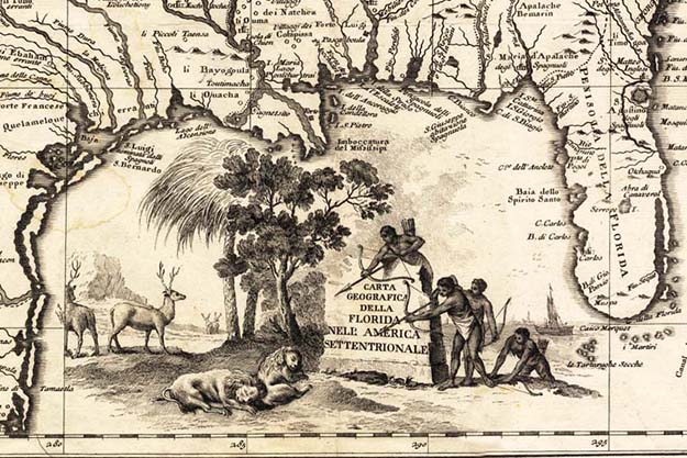
The above detail is from a map made in about 1790, showing locations
of ethnic |
This is a heterogeneous collection of old and very rare maps of various parts of the world donated by an estate in Santa Barbara, California. Numbers 1-38 (but no #24). #1 has 20 maps from an atlas; #3 has 22 separate maps. This inventory draws from cartographic analysis by John F. and Beatrice C. Reed, 1984, in the collection case file, which also contains an itemized listing in receipt for the legacy of Margarita P. (Margaret) Cutter, deceased, of Santa Barbara, California. Map #33 is the only solely Southwest U.S. map in collection. Smaller maps are in a flat box; larger items are in a map case drawer. Each of the maps has been inventoried and all but the bound set have been encapsulated.
Administrative information
Acquisition of this collection: The College’s ownership of this collection (accession 1970:02007) is documented by Fort Lewis College President Rexer Berndt's letter to Charles L. Youngman, Librarian, Durango Public Library, Feb. 6, 1970; also, by a memo from the Center’s director, Robert Delaney, to Youngman, Feb. 5, 1970, and court documents regarding the settlement of the Margarita P. Cutter estate in Santa Barbara County, California (5 pages, circa March 25, 1970).
About the organization of this collection: The Center has left the maps in the order in which they were described by President Reed.
Processing information: This guide was produced by Todd Ellison, Certified Archivist, Center of Southwest Studies; the text was last revised on July 10, 2003. Initial data entry was by Tom Schmidt and Melanie Ellison in July 2002.
Photo reproduction and digital access: The 12" x 16" color world map made in Venice in 1776 by Antonio Zatta was photographed in color by Marona Photography on September 11, 1997, for use in the full-color promotional brochure that was used during fundraising for the new Center of Southwest Studies building. Digitization was by Consultant Nik Kendziorski in July 2003, as part of the Center of Southwest Studies' Western Trails grant through the Colorado Digitization Program (as it was formerly known). Stitching of oversize maps (and staff training in such) was by volunteer Ed Lederman in the fall of 2003.
| Through its partnership with the Colorado Digitization Program (CDP -- now the Collaborative Digitization Program) the Center of Southwest Studies has digitized many thousands of images selected from a number of collections, for viewing on the Web for educational purposes and research. To search for digital images at the Center of Southwest Studies and elsewhere, go to Heritage West. | |
|
The CDP is supported through a National Leadership Grant to the University of Denver Penrose Library from the Institute of Museum and Library Services (a federal grant-making agency in Washington, D.C., which fosters innovation, leadership and a lifetime of learning, by supporting museums and libraries) with additional assistance from the Colorado State Library, and the Colorado Regional Library Systems. |
|

Alphabetical list of map titles and
accession numbers (with links to the item-level
descriptions):
Search suggestion:
you can search this web page by
name using the Edit-> Find in Page (Ctrl+F) feature on your Web
browser.
A general map of North America, drawn from the best surveys of 1795 /map number 1970:02007.11
A map of the United States of America, as settled by the Peace of 1783 /map number 1970:02007.09
A new and accurate map of the world, "drawn according to ye truest descriptions, latest discoveries and best observations that have been made by English or strangers" /map number 1970:02007.26
A new map of East India /map number 1970:02007.27
A new map of North America showing all the new discoveries, 1797 /map number 1970:02007.05
A new map of the northwest coast of Asia and the northwest coast of America, with the late Russian discoveries /map number 1970:02007.04
A new mappe of the Romane Empire /map number 1970:02007.25
Africa, secondo le ultime osservazioni dell Accademia Reale delle Scienze di Parigi [map of Africa] /map number 1970:02007.01R
America, secondo le ultime osservazioni dell Accademia Reale delle Scienze di Parigi [map of the Western Hemisphere -- the Americas] /map number 1970:02007.01S
America, with those known parts in that unknown world, both people and manner of buildings /map number 1970:02007.12
Americae Nova descriptio [map of new America: North and South America and a bit of northeast Asia] /map number 1970:02007.15
Amerique septentrionale publiee sous les auspices de Monseigneurf le Duc D’Orleans [map of North America] /map number 1970:02007.37
An accurate map of North America drawn from the Sieur Robert with improvements /map number 1970:02007.08
Asia, secondo le ultime osservazioni dell Accademia Reale delle Scienze [map of Asia] /map number 1970:02007.01Q
Atlantis Insula /map number 1970:02007.10
Barbaria, Egitto, Nigrizia, Guinea, Nubia, Abissina. Del Giografo Lamarche [map of Barbaria, et al. -- North Africa, south to the Equator] /map number 1970:02007.03L
Carta del Mar Pacifico del Nord [map of the North Pacific] /map number 1970:02007.14
Carta del Paese Degli Svizzeri, e Della Savoja, secondo I grandi dell Accademia delle Scienze di Parigi [map of Switzerland and Savoja] /map number 1970:02007.01F
Carta del Paesi Bassi [map of the Low Countries of northern Europe] /map number 1970:02007.03A
Carta dell Antico Egito [map of ancient Egypt] /map number 197002007.07
Carta delle regioni e luoghi di cuisiparla nel Nuovo Testamento [map of the New Testament Land / Palestine / Judea] /map number 1970:02007.03J
Carta geografica della Florida dell America settentrionale [map of Florida: the southeastern portion of the present day United States; but it includes much of the Southwest also] /map number 1970:02007.36
Cartadella Gran Bretagna, sopra li grandi dell Accademia di Parigi [map of the British Isles] /map number 1970:02007.01J
Carte des nouvelles descouvertes, au Nord de la Mer du Sud, tant a l’Est de la Siberie dt du Kamtchatka, qu’al Ouest de la Nouvelle France [map of new discoveries to the north of La Mer du Sud] /map number 1970:02007.35
Europa, secondo le ultime osservazioni dell Academia Reale delle Scienze [map of Europe] /map number 1970:02007.01B
Francia, secondo le ultime osservazioni dell Accademia Reale delle Scienze [map of France] /map number 1970:02007.01D
Grecia, antica e moderna [map of Greece, ancient and modern] /map number 1970:02007.01O
Imperio D'Allemagna, diviso in dieci circola, secondo le osservazioni dell Academia Reale delle Scienze e di altri autori antichi e moderni [map of Germany] /map number 1970:02007.01G
Italia, secondo i gradi dell Academia delle Scienze di Parigi [map of Italy] /map number 1970:02007.01C
Judea, ex Nuovo Testamento descripta [map of Judea] /map number 1970:02007.01T
L’Amerique Meridionale [map of South America] /map number 1970:02007.34
L’Amerique septentrionale [map of North America and the northern tip of South America] /map number 1970:02007.32
La Francia divisa in dipartimenti [map of France with its Departments] /map number 1970:02007.03Q
La Francia divisa in provincie [map of France ] /map number 1970:02007.03D
La Grecia e parte della Servia Novamente delineata [map of Greece and part of Serbia] /map number 1970:02007.03S
La Polonia di nuova projezione [map of Poland] /map number 1970:02007.03H
La Spagna e Portogallo [map of Spain and Portugal] /map number 1970:02007.03G
La Turchia in Europa, sopra le osservazioni dell Accademia delle Scienze di Parigi [map of Turkey in Europe] /map number 1970:02007.01N
L'Africa divisa nei suoi principali stati [map of Africa] /map number 1970:02007.03T
L'Alemagna divisa ne'suci differenti stati [map of Germany] /map number 1970:02007.03K
L'America meridionale, divisa nei suoi principali stati [map of South America] /map number 1970:02007.03I
L'America settentrionale, divisa ne'suoi princpali stati [map of North America] /map number 1970:02007.03P
L'America settentrionale, nuouamente corretta, et accresciuta secondo le relationi pui moderne, da Guglielmo Sansone geografo an SM Chriftianis /map number 1970:02007.16
L'Asia con nuere osservazioni astronomiche [map of Asia ] /map number 1970:02007.03E
Le Corone del Nord Ossiano li Regni di Svezia, Norvegia e Danimarca [map of Scandinavia] /map number 1970:02007.03U
Le XVII. Provincie dei Paesi Bassi, secondo I grandi dell Accademia delle Scienze di Parigi [map of the Low Countries of northern Europe] /map number 1970:02007.01E
L'Estrenadyra e ka Castiglia nuova di nuova projezione [map of Spain and outline of Portugal, on a new projection] /map number 1970:02007.28
Li due circoli dell alto e basso Reno, secondo le osservazioni dell Accademia delle Scienze [map of Reno] /map number 1970:02007.01H
Li Regni D'Inghilterra Scozia ed Irlanda [map of the British Isles] /map number 1970:02007.03R
Li Svizzeri e stati annessi di nuera projezione [map of Switzerland] /map number 1970:02007.03M
L'Impero della China con le Isole del Giapone [map of China] /map number 1970:02007.03N
L'Impero della China per uso della storia generale de Viaggi [map of China] /map number 1970:02007.31
L'Italia Meridionale che contiene, li Regni di Napoli Esicilia [map of Southern Italy and Sicily] /map number 1970:02007.03V
Mappa dell' America settentrionale [map of North America -- eastern portion] /map number 1970:02007.21
Mappamondo [map of the world] /map number 1970:02007.01A
Mappe monde de nos connoissances nouvelle dediee au progres [map of the world] /map number 1970:02007.18
Mappe monde ou description du globe terrestre [map of the world] /map number 197002007.17
Moscovia [map of Moscovia] /map number 1970:02007.01M
North America, drawn from the latest and best authorities /map number 1970:02007.22
Nova totius terrarum orbis geographica ac hydrographica tabula [map of the world] /map number 1970:02007.13
Nuove Scoperte De'Russi al Nord del Mare del Sud si nell Asia, che nell America [map of the world north of the Tropic of Cancer] /map number 1970:02007.20
Nvoua carta dell Impero del Gran Mogul [a new map of the Empire of the Gran Mogol] /map number 1970:02007.19
Orbis Terrae compendiosa descriptio [map of the world] /map number 1970:02007.06
Parte occidentale del Regno Italico [map of the Kingdom of Italy (western)] /map number 1970:02007.03B
Parte orientale del Regno Italico, divisa in provincie, delineata sulle recenti osservazioni astronomiche [map of the Kingdom of Italy (eastern)] /map number 1970:02007.03C
Polonia, secondo le osservazioni ni dell Accademia di Parigi [map of Poland] /map number 1970:02007.01L
Sa Russia Europea divisa in governi [map of European Russia] /map number 1970:02007.03O
Spagna, secondo le ultime osservazioni dell Accademia Reale delle Scienze [map of Spain] /map number 1970:02007.01I
Spanish North America /map number 1970:02007.33
Svezia Norvegie Danimarca, secondo I grandi dell Accademia delle Scienze di Parigi [map of Scandinavia] /map number 1970:02007.01K
The Kingdome of China /map number 1970:02007.29
The world, on Mercator's projection /map number 1970:02007.23
Turchia d'Asia Esegiota sopra osservazioni astronomiche [map of Turkey in Asia] /map number 1970:02007.03F
Turchia nell Asia, antioca e moderna [map of Turkey in Asia -- ancient and modern] /map number 1970:02007.01P
[Untitled map of North and South America and surrounding oceans] /map number 1970:02007.30
[Untitled map of the world] /map number 1970:02007.38
[Untitled map showing the east coast of North
and South America, et al.] /map number 1970:02007.02
Item-level description of the maps,
with links to the digital image (SW maps only)
Listed by accession number plus the map's item number.
Item
Number:
1970:02007.01A
Date of
map:
late 17th
century or early 18th century
Title: Mappamondo [map of the world]
Cartographer (corporate name): Academy of Sciences (Paris) Height (inches): 7.5 Width (inches): 10
This is one map (page 6) in a bound volume
of twenty maps that are from a geography textbook that is missing its table of
contents. The page numbering of
the maps is not consecutive.
The titles are in Italian, derived from an edition issued by the
Royal Academy of Sciences in Paris, France.
Each map includes lines of latitude and lon
Item
Number:
1970:02007.01B
Date of
map:
late 17th
century or early 18th century
Title: Europa, secondo le ultime osservazioni dell Academia Reale delle Scienze [map of Europe]
Cartographer (corporate name): Academy of Sciences (Paris) Height (inches): 7.5 Width (inches): 10
This is one map (page 7)
in a bound volume of twenty maps that are
from a geography textbook that is missing its table of contents. The
page numbering of the maps is not consecutive.
The titles are in Italian, derived from an edition issued by the
Royal Academy of Sciences in Paris, France.
Each map includes lines of latitude and lon
Item Number: 1970:02007.01C Date of map: late 17th century or early 18th century
Title: Italia, secondo i gradi dell Academia delle Scienze di Parigi [map of Italy]
Cartographer (corporate name): Academy of Sciences (Paris) Height (inches): 7.5 Width (inches): 10
This is one map (page 9) in a bound volume
of twenty maps that are from a geography textbook
that is missing its table of contents. The page numbering of the maps is
not consecutive. The titles are
in Italian, derived from an edition issued by
Item Number: 1970:02007.01D Date of map: late 17th century or early 18th century
Title: Francia, secondo le ultime osservazioni dell Accademia Reale delle Scienze [map of France]
Cartographer (corporate name): Academy of Sciences (Paris) Height (inches): 7.5 Width (inches): 10
This is one map (page 38) in a bound
volume of twenty maps that are from a geography textbook
that is missing its table of contents. The page numbering of the maps is
not consecutive. The titles are
in Italian, derived from an edition issued by
Item Number: 1970:02007.01E Date of map: late 17th century or early 18th century
Title: Le XVII. Provincie dei Paesi Bassi, secondo I grandi dell Accademia delle Scienze di Parigi [map of the Low Countries of northern Europe]
Cartographer (corporate name): Academy of Sciences (Paris) Height (inches): 7.5 Width (inches): 10
This is one map (page
61) in a bound volume of twenty maps that are from a geography textbook
that is missing its table of contents. The page numbering of the maps is
not consecutive. The titles are
in Italian, derived from an edition issued by
Item Number: 1970:02007.01F Date of map: late 17th century or early 18th century
Title: Carta del Paese Degli Svizzeri, e Della Savoja, secondo I grandi dell Accademia delle Scienze di Parigi [map of Switzerland and Savoja]
Cartographer (corporate name): Academy of Sciences (Paris) Height (inches): 7.5 Width (inches): 10
This is one map (page 70) in a bound
volume of twenty maps that are from a geography textbook
that is missing its table of contents. The page numbering of the maps is
not consecutive. The titles are
in Italian, derived from an edition issued by
Item Number: 1970:02007.01G Date of map: late 17th century or early 18th century
Title: Imperio D'Allemagna, diviso in dieci circola, secondo le osservazioni dell Academia Reale delle Scienze e di altri autori antichi e moderni [map of Germany]
Cartographer (corporate name): Academy of Sciences (Paris) Height (inches): 7.5 Width (inches): 10
This is one map (page 75) in a bound volume of twenty maps that are from a geography textbook that is missing its table of contents. The page numbering of the maps is not consecutive. The titles are in Italian, derived from an edition issued by the Royal Academy of Sciences in Paris, France. Each map includes lines of latitude and longitude. Because the Royal Academy of Sciences of Paris was established in 1666, it is estimated that this textbook was published in the late 17th century or the early 18th century.
Item Number: 1970:02007.01H Date of map: late 17th century or early 18th century
Title: Li due circoli dell alto e basso Reno, secondo le osservazioni dell Accademia delle Scienze [map of Reno]
Cartographer (corporate name): Academy of Sciences (Paris) Height (inches): 7.5 Width (inches): 10
This is one map (page 92) in a bound
volume of twenty maps that are from a geography textbook
that is missing its table of contents. The page numbering of the maps is
not consecutive. The titles are
in Italian, derived from an edition issued by
Item Number: 1970:02007.01I Date of map: late 17th century or early 18th century
Title: Spagna, secondo le ultime osservazioni dell Accademia Reale delle Scienze [map of Spain]
Cartographer (corporate name): Academy of Sciences (Paris) Height (inches): 7.5 Width (inches): 10
This is one map (page 118) in a bound
volume of twenty maps that are from a geography textbook
that is missing its table of contents. The page numbering of the maps is
not consecutive. The titles are
in Italian, derived from an edition issued by
Item Number: 1970:02007.01J Date of map: late 17th century or early 18th century
Title: Cartadella Gran Bretagna, sopra li grandi dell Accademia di Parigi [map of the British Isles]
Cartographer (corporate name): Academy of Sciences (Paris) Height (inches): 7.5 Width (inches): 10
This is one map (page 133) in a bound
volume of twenty maps that are from a geography textbook
that is missing its table of contents. The page numbering of the maps is
not consecutive. The titles are
in Italian, derived from an edition issued by
Item Number: 1970:02007.01K Date of map: late 17th century or early 18th century
Title: Svezia Norvegie Danimarca, secondo I grandi dell Accademia delle Scienze di Parigi [map of Scandinavia]
Cartographer (corporate name): Academy of Sciences (Paris) Height (inches): 7.5 Width (inches): 10
This is one map (page 142) in a bound
volume of twenty maps that are from a geography textbook
that is missing its table of contents. The page numbering of the maps is
not consecutive. The titles are
in Italian, derived from an edition issued by
Item Number: 1970:02007.01L Date of map: late 17th century or early 18th century
Title: Polonia, secondo le osservazioni ni dell Accademia di Parigi [map of Poland]
Cartographer (corporate name): Academy of Sciences (Paris) Height (inches): 7.5 Width (inches): 10
This is one map (page 152) in a bound
volume of twenty maps that are from a geography textbook
that is missing its table of contents. The page numbering of the maps is
not consecutive. The titles are
in Italian, derived from an edition issued by
Item Number: 1970:02007.01M Date of map: late 17th century or early 18th century
Title: Moscovia [map of Moscovia]
Cartographer (corporate name): Academy of Sciences (Paris) Height (inches): 7.5 Width (inches): 10
This is one map (page 158) in a bound
volume of twenty maps that are from a geography textbook
that is missing its table of contents. The page numbering of the maps is
not consecutive. The titles are
in Italian, derived from an edition issued by
Item Number: 1970:02007.01N Date of map: late 17th century or early 18th century
Title: La Turchia in Europa, sopra le osservazioni dell Accademia delle Scienze di Parigi
Cartographer (corporate name): Academy of Sciences (Paris) Height (inches): 7.5 Width (inches): 10
This is one map (page 163) in a bound
volume of twenty maps that are from a geography textbook
that is missing its table of contents. The page numbering of the maps is
not consecutive. The titles are
in Italian, derived from an edition issued by
Item Number: 1970:02007.01O Date of map: late 17th century or early 18th century
Title: Grecia, antica e moderna [map of Greece, ancient and modern]
Cartographer (corporate name): Academy of Sciences (Paris) Height (inches): 7.5 Width (inches): 10
This is one map (page 169) in a bound
volume of twenty maps that are from a geography textbook
that is missing its table of contents. The page numbering of the maps is
not consecutive. The titles are
in Italian, derived from an edition issued by
Item Number: 1970:02007.01P Date of map: late 17th century or early 18th century
Title: Turchia nell Asia, antioca e moderna [map of Turkey in Asia -- ancient and modern]
Cartographer (corporate name): Academy of Sciences (Paris) Height (inches): 7.5 Width (inches): 10
This is one map (page 175) in a bound
volume of twenty maps that are from a geography textbook
that is missing its table of contents. The page numbering of the maps is
not consecutive. The titles are
in Italian, derived from an edition issued by
Item Number: 1970:02007.01Q Date of map: late 17th century or early 18th century
Title: Asia, secondo le ultime osservazioni dell Accademia Reale delle Scienze [map of Asia]
Cartographer (corporate name): Academy of Sciences (Paris) Height (inches): 7.5 Width (inches): 10
This is one map (page 176) in a bound
volume of twenty maps that are from a geography textbook
that is missing its table of contents. The page numbering of the maps is
not consecutive. The titles are
in Italian, derived from an edition issued by
Item Number: 1970:02007.01R Date of map: late 17th century or early 18th century
Title: Africa, secondo le ultime osservazioni dell Accademia Reale delle Scienze di Parigi [map of Africa]
Cartographer (corporate name): Academy of Sciences (Paris) Height (inches): 7.5 Width (inches): 10
This is one map (page 205) in a bound
volume of twenty maps that are from a geography textbook
that is missing its table of contents. The page numbering of the maps is
not consecutive. The titles are
in Italian, derived from an edition issued by
Item Number: 1970:02007.01S Date of map: late 17th century or early 18th century
Title: America, secondo le ultime osservazioni dell Accademia Reale delle Scienze di Parigi [map of the Western Hemisphere -- the Americas]
Cartographer (corporate name): Academy of Sciences (Paris) Height (inches): 7.5 Width (inches): 10
This is one map (page 220) in a bound volume of twenty maps that are from a geography textbook that is missing its table of contents. The page numbering of the maps is not consecutive. The titles are in Italian, derived from an edition issued by the Royal Academy of Sciences in Paris, France. Each map includes lines of latitude and longitude. Because the Royal Academy of Sciences of Paris was established in 1666, it is estimated that this textbook was published in the late 17th century or the early 18th century. This map of North America is remarkably accurate with respect to size and length:width ratio.
Item Number: 1970:02007.01T Date of map: late 17th century or early 18th century
Title: Judea, ex Nuovo Testameto descripta [map of Judea]
Cartographer (corporate name): Academy of Sciences (Paris) Height (inches): 7.5 Width (inches): 10
This is one map (page 356?)-- the last
page in a bound volume of twenty maps that are from a geography textbook
that is missing its table of contents. The page numbering of the maps is
not consecutive. The titles are
in Italian, derived from an edition issued by
Item Number: 1970:02007.02 Date of map: 1530 Place of publication: [Venice?]
Title: [Untitled map showing the east coast of North and South America, et al.]
Cartographer (personal name): Battista Agnese Height (inches): 10.2 Width (inches): 15.2
This map only depicts coast lines, which makes a detailed interpretation of this chart difficult. The original was printed on parchment in the 16th century by Giambattista Agnese (active 1526-1533); this is a copy made in 1910 by H. Lodeman, Staats Bibliothek, Munich.
Item Number: 1970:02007.03A Date of map: 1810 Place of publication: Venice
Title: Carta del Paesi Bassi [map of the Low Countries of northern Europe]
Cartographer (personal name): Giorgio Valerio Pasquali, engraver Height (inches) 7.5 Width (inches): 10.5
This is one map (page 11) in a collection of 22 maps produced for the London Magazine. These maps represent a standardized cartography, with faithfully reproduced major features -- both political and physiographic -- throughout. The labeling is in Italian.
Item Number: 1970:02007.03B Date of map: 1810 Place of publication: Venice
Title: Parte occidentale del Regno Italico [map of the Kingdom of Italy (western)]
Cartographer (personal name): Giorgio Valerio Pasquali, engraver Height (inches): 7.5 Width (inches): 10
This is one map (page 6) in a collection of 22 maps produced for the London Magazine. These maps represent a standardized cartography, with faithfully reproduced major features -- both political and physiographic -- throughout. The labeling is in Italian.
Item Number: 1970:02007.03C Date of map: 1810 Place of publication: Venice
Title: Parte orientale del Regno Italico, divisa in provincie, delineata sulle recenti osservazioni astronomiche [map of the Kingdom of Italy (eastern)]
Cartographer (personal name): Giorgio Valerio Pasquali, engraver Height (inches): 7.5 Width (inches): 10.5
This is one map (page 7) in a collection of 22 maps produced for the London Magazine. These maps represent a standardized cartography, with faithfully reproduced major features -- both political and physiographic -- throughout. The labeling is in Italian.
Item Number: 1970:02007.03D Date of map: 1810 Place of publication: Venice
Title: La Francia divisa in provincie [map of France ]
Cartographer (personal name): Giorgio Valerio Pasquali, engraver Height (inches): 7.5 Width (inches): 10.5
This is one map (page 9) in a collection of 22 maps produced for the London Magazine. These maps represent a standardized cartography, with faithfully reproduced major features -- both political and physiographic -- throughout. The labeling is in Italian.
Item Number: 1970:02007.03E Date of map: 1810 Place of publication: Venice
Title: L'Asia con nuere osservazioni astronomiche [map of Asia ]
Cartographer (personal name): Giorgio Valerio Pasquali, engraver Height (inches): 7.5 Width (inches): 10.5
This is one map (page 20) in a collection of 22 maps produced for the London Magazine. These maps represent a standardized cartography, with faithfully reproduced major features -- both political and physiographic -- throughout. The labeling is in Italian.
Item Number: 1970:02007.03F Date of map: 1810 Place of publication: Venice
Title: Turchia d'Asia Esegiota sopra osservazioni astronomiche [map of Turkey in Asia]
Cartographer (personal name): Giorgio Valerio Pasquali, engraver Height (inches): 7.5 Width (inches): 10.5
This is one map (page 21) in a collection of 22 maps produced for the London Magazine. These maps represent a standardized cartography, with faithfully reproduced major features -- both political and physiographic -- throughout. The labeling is in Italian.
Item Number: 1970:02007.03G Date of map: 1810 Place of publication: Venice
Title: La Spagna e Portogallo [map of Spain and Portugal]
Cartographer (personal name): Giorgio Valerio Pasquali, engraver Height (inches): 7.5 Width (inches): 10.5
This is one map (page 15) in a collection of 22 maps produced for the London Magazine. These maps represent a standardized cartography, with faithfully reproduced major features -- both political and physiographic -- throughout. The labeling is in Italian.
Item Number: 1970:02007.03H Date of map: 1810 Place of publication: Venice
Title: La Polonia di nuova projezione [map of Poland]
Cartographer (personal name): Giorgio Valerio Pasquali, engraver Height (inches): 7.5 Width (inches): 10.5
This is one map (page 14) in a collection of 22 maps produced for the London Magazine. These maps represent a standardized cartography, with faithfully reproduced major features -- both political and physiographic -- throughout. The labeling is in Italian.
Item Number: 1970:02007.03I Date of map: 1810 Place of publication: Venice
Title: L'America meridionale, divisa nei suoi principali stati [map of South America]
Cartographer (personal name): Giorgio Valerio Pasquali, engraver Height (inches): 7.5 Width (inches): 10.5
This is one map (page 26) in a collection of 22 maps produced for the London Magazine. These maps represent a standardized cartography, with faithfully reproduced major features -- both political and physiographic -- throughout. The labeling is in Italian.
Item Number: 1970:02007.03J Date of map: 1810 Place of publication: Venice
Title: Carta delle regioni e luoghi di cuisiparla nel Nuovo Testamento [map of the New Testament Land / Palestine / Judea]
Cartographer (personal name): Giorgio Valerio Pasquali, engraver Height (inches): 7.5 Width (inches): 10.5
This is one map (page 27) in a collection of 22 maps produced for the London Magazine. These maps represent a standardized cartography, with faithfully reproduced major features -- both political and physiographic -- throughout. The labeling is in Italian.
Item Number: 1970:02007.03K Date of map: 1810 Place of publication: Venice
Title: L'Alemagna divisa ne'suci differenti stati [map of Germany]
Cartographer (personal name): Giorgio Valerio Pasquali, engraver Height (inches): 7.5 Width (inches): 10.5
This is one map (page 13) in a collection of 22 maps produced for the London Magazine. These maps represent a standardized cartography, with faithfully reproduced major features -- both political and physiographic -- throughout. The labeling is in Italian.
Item Number: 1970:02007.03L Date of map: 1810 Place of publication: Venice
Title: Barbaria, Egitto, Nigrizia, Guinea, Nubia, Abissina. Del Giografo Lamarche [map of Barbaria, et al. -- North Africa, south to the Equator]
Cartographer (personal name): Giorgio Valerio Pasquali, engraver Height (inches): 7.5 Width (inches): 10.5
This is one map (page 24) in a collection of 22 maps produced for the London Magazine. These maps represent a standardized cartography, with faithfully reproduced major features -- both political and physiographic -- throughout. The labeling is in Italian.
Item Number: 1970:02007.03M Date of map: 1810 Place of publication: Venice
Title: Li Svizzeri e stati annessi di nuera projezione [map of Switzerland]
Cartographer (personal name): Giorgio Valerio Pasquali, engraver Height (inches): 7.5 Width (inches): 10.5
This is one map (page 12) in a collection of 22 maps produced for the London Magazine. These maps represent a standardized cartography, with faithfully reproduced major features -- both political and physiographic -- throughout. The labeling is in Italian.
Item Number: 1970:02007.03N Date of map: 1810 Place of publication: Venice
Title: L'Impero della China con le Isole del Giapone [map of China]
Cartographer (personal name): Giorgio Valerio Pasquali, engraver Height (inches): 7.5 Width (inches): 10.5
This is one map (page 22) in a collection of 22 maps produced for the London Magazine. These maps represent a standardized cartography, with faithfully reproduced major features -- both political and physiographic -- throughout. The labeling is in Italian.
Item Number: 1970:02007.03O Date of map: 1810 Place of publication: Venice
Title: Sa Russia Europea divisa in governi [map of European Russia]
Cartographer (personal name): Giorgio Valerio Pasquali, engraver Height (inches): 7.5 Width (inches): 10.5
This is one map (page 18) in a collection of 22 maps produced for the London Magazine. These maps represent a standardized cartography, with faithfully reproduced major features -- both political and physiographic -- throughout. The labeling is in Italian.
Item
Number:
1970:02007.03P
Date of
map:
1810
Place
of publication:
Venice
Title: L'America settentrionale, divisa ne'suoi princpali stati [map of North America]
Cartographer (personal name): Giorgio Valerio Pasquali, engraver Height (inches): 7.5 Width (inches): 10.5
This is one map (page 25) in a collection of 22 maps produced for the London Magazine. These maps represent a standardized cartography, with fairly faithfully reproduced major features -- both political and physiographic -- throughout. The labeling is in Italian. On this map, Canada is shown as the large area northerly with Quebec City/ Montreal. Some attention is given to colonial possessions. The polar regions are not well done; a large Mare d'Ouest is obviously in error.
Item Number: 1970:02007.03Q Date of map: 1810 Place of publication: Venice
Title: La Francia divisa in dipartimenti [map of France with its Departments]
Cartographer (personal name): Giorgio Valerio Pasquali, engraver Height (inches): 7.5 Width (inches): 10.5
This is one map (page 10) in a collection of 22 maps produced for the London Magazine. These maps represent a standardized cartography, with faithfully reproduced major features -- both political and physiographic -- throughout. The labeling is in Italian.
Item Number: 1970:02007.03R Date of map: 1810 Place of publication: Venice
Title: Li Regni D'Inghilterra Scozia ed Irlanda [map of the British Isles]
Cartographer (personal name): Giorgio Valerio Pasquali, engraver Height (inches): 7.5 Width (inches): 10.5
This is one map (page 16) in a collection of 22 maps produced for the London Magazine. These maps represent a standardized cartography, with faithfully reproduced major features -- both political and physiographic -- throughout. The labeling is in Italian.
Item Number: 1970:02007.03S Date of map: 1810 Place of publication: Venice
Title: La Grecia e parte della Servia Novamente delineata [map of Greece and part of Serbia]
Cartographer (personal name): Giorgio Valerio Pasquali, engraver Height (inches): 7.5 Width (inches): 10.5
This is one map (page 19) in a collection of 22 maps produced for the London Magazine. These maps represent a standardized cartography, with faithfully reproduced major features -- both political and physiographic -- throughout. The labeling is in Italian.
Item Number: 1970:02007.03T Date of map: 1810 Place of publication: Venice
Title: L'Africa divisa nei suoi principali stati [map of Africa]
Cartographer (personal name): Giorgio Valerio Pasquali, engraver Height (inches): 7.5 Width (inches): 10.5
This is one map (page 23) in a collection of 22 maps produced for the London Magazine. These maps represent a standardized cartography, with faithfully reproduced major features -- both political and physiographic -- throughout. The labeling is in Italian.
Item Number: 1970:02007.03U Date of map: 1810 Place of publication: Venice
Title: Le Corone del Nord Ossiano li Regni di Svezia, Norvegia e Danimarca [map of Scandinavia]
Cartographer (personal name): Giorgio Valerio Pasquali, engraver Height (inches): 7.5 Width (inches): 10.5
This is one map (page 17) in a collection of 22 maps produced for the London Magazine. These maps represent a standardized cartography, with faithfully reproduced major features -- both political and physiographic -- throughout. The labeling is in Italian.
Item Number: 1970:02007.03V Date of map: 1810 Place of publication: Venice
Title: L'Italia Meridionale che contiene, li Regni di Napoli Esicilia [map of Southern Italy and Sicily]
Cartographer (personal name): Giorgio Valerio Pasquali, engraver Height (inches): 7.5 Width (inches): 10.5
This is one map (page 8) in a collection of 22 maps produced for the London Magazine. These maps represent a standardized cartography, with faithfully reproduced major features -- both political and physiographic -- throughout. The labeling is in Italian.
Item Number: 1970:02007.04 Date of map: 1770 Height (inches): 8.25 Width (inches): 10.5
Title: A new map of the northwest coast of Asia and the northwest coast of America, with the late Russian discoveries
This map, produced for the London Magazine, shows several Russian voyages of discovery, and communities in Asia. It only shows some coast lines of North America. The proportions North-South and East-West in North America are vague. Conic projection.
Item
Number:
1970:02007.05
Date of
map:
1797
Height
(inches):
8.5
Width (inches):
10
Title: A new map of North America showing all the new discoveries, 1797
This map shows New Albion in California (California is depicted as a peninsula), the headwaters of the Mississippi River and the names of the new states along the Atlantic Seaboard. Drake's Harbour is labeled, as are the Gulfs of Mexico, Florida, and California. Shows locations of ethnic groups and communities. The name Canada does not appear on this map, but Quebec City and Montreal are both shown. Curved projection.
Item
Number:
1970:02007.06
Date of
map:
1560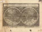
Title: Orbis Terrae compendiosa descriptio [map of the world]
Cartographer (personal name): F. P., engraver Height (inches): 8.25 Width (inches): 11
This map shows locations of some communities (mostly in the Eastern Hemisphere), and mentions some navigational aids. Mentions the Seven Cities of Cibola, depicts California and Greenland as peninsulas and Terra Australis beneath both hemispheres with both Africa and South American separated from it. New Guinea is disproportionately large, and the Western Hemisphere land masses are inaccurately depicted in ratio of length to width. Canada's boundaries are not clearly drawn, and most of North America is not depicted. Curved projection.
Item Number: 1970:02007.07 Date of map: 1760
Title: Carta dell Antico Egito [map of ancient Egypt] Height (inches): 8.25 Width (inches): 12.5
This map, from the first volume of an atlas, shows some oases and outposts, the Great Pyramids of Egypt, fluvial vegetation and animals, and locations of ethnic groups and communities in Egypt and Ethiopia.
Item
Number:
1970:02007.08
Date of
map:
1750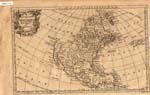
Title: An accurate map of North America drawn from the Sieur Robert, with improvements
Cartographer (personal name): Sieur Robert Height (inches): 8.5 Width (inches): 14
This 18th century map (not dated) includes mention of the westward extension of the southern American colonies and shows locations of communities in the Southwest, East Coast, and Central America. It depicts Canada as a large area to the north of the U.S., California as a peninsula, and Greenland as a peninsula separated from North America by the Davis Straits. The entire northwestern part of North America is unmapped. The map includes a few notes regarding historical explorations. Curved projection.
Item Number: 1970:02007.09 Date of map: 1783
Title: A map of the United States of America, as settled by the Peace of 1783
Cartographer (personal name): I. Fielding Height (inches): 9.25 Width (inches): 11.2
This map shows locations of ethnic groups and communities, and alludes to some oceanic features. An off-shore line is called "the limited boundary of the seacoast of the United States." The map clearly indicates the boundaries of Canada, Hudson's Bay, and Louisiana. The U.S. boundary of Canada is prominent, but little north of that boundary is depicted except for Montreal. Mercator projection.
Item
Number:
1970:02007.10
Date of
map:
1595
Place
of publication:
Amsterdam
Title: Atlantis Insula
Cartographer
(personal name):
Nicolao Sanson [Nicholas Sanson]
Height
(inches):
16.5
Width (inches):
22.2
This map of the Western Hemisphere and edges of the Eastern Hemisphere shows the locations of a few communities and depicts Greenland as a peninsula extending from the North American sector of the boreal land mass, which itself continues to Asia. Canada is labeled Gadinus. Both California and Tierra del Fuego are shown as islands. It is possible that the 1595 year attribution is in error. Conical projection.
Item
Number:
1970:02007.11
Date of
map:
1795 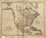
Title:
A
general map of North America, drawn from the best surveys of 1795
Height
(inches):
16
Width (inches):
19.2
This map shows the locations of states and cities on the Eastern Seaboard and a few settlements elsewhere. Indians of the Far North are named. The map indicates a sea described by 18th century explorers, with Greenland as a peninsula north of North America and divided into east and west parts. The map infers (by reference to explorers of the 18th century) the existence of a sea (Arctic Ocean, seen by MacKenzie in 1789); Canada is depicted as a large area south of Labrador, north of the present U.S., and south of New South Wales. Curved projection.
|
Front:
Rear two pages\ |
 |
 |
 |
Item Number: 1970:02007.12 Date of map: 1626
Title: America, with those known parts in that unknown world, both people and manner of buildings
Cartographer
(personal name):
John Speed
Height
(inches):
17
Width (inches):
21.5
This map shows locations of communities, with Native towns modeled in the margins of the map. It refers to the Northwest Passage and shows Greenland as a peninsula of the Arctic Continent and depicts whales in the oceans. It shows the legendary gold-rich lost city of El Dorado/ Manoa and Lake Parime. Both California and Tierra del Fuego are shown as islands. Canada is drawn as a small area west of the St. Lawrence River. The Rocky Mountains and Appalachians are connected by an east-west range. The Colorado River (Rio del Norte) is shown as if it were draining the Great Salt Lake. The Great Lakes are not shown. Curved projection.
|
Front:
Rear two pages\ |
 |
 |
 |
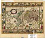
Item Number: 1970:02007.13 Date of map: 1740
Title: Nova totius terrarum orbis geographica ac hydrographica tabula [map of the world]
Cartographer
(personal name):
Guilielmo
Blaeou
Height
(inches):
19.5
Width (inches):
23.2
Some historical information is included on the map. Shows locations of some ethnic groups and communities, and mentions some navigational aids. Shows the legendary Manoa and Lake Parime. Depicts California and Tierra del Fuego as peninsulas. Western and northern North America are not mapped, nor are eastern and northern Asia. The Seven Wonders of the World and the Spirit of the Four Elements are shown in the margins. Mercator projection.
Item
Number:
1970:02007.14
Date of
map:
1796
Place
of publication:
Venice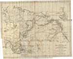
Title: Carta del Mar Pacifico del Nord [map of the North Pacific]
Cartographer (personal name): Antonio Zatta Height (inches): 18.7 Width (inches): 23.5
This map, produced for the purpose of showing the routes of the explorations made by Cook and Meares, reports citations of oceans seen in the Arctic north of North America, depicts shoals off of northern North America, shows the routes of the explorations by Cook and Meares, and shows locations of some ethnic groups and communities in North America and Asia. Mercator projection.
Item
Number:
1970:02007.15
Date of
map:
1652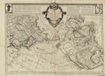
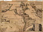
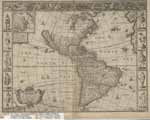
Title: Americae Nova descriptio [map of new America: North and South America and a bit of northeast Asia]
Cartographer (personal name): Nicolaum Visscher Height (inches): 19.5 Width (inches): 23.5
This map makes reference to Magellan's voyage. It shows locations of some ethnic groups and communities in North and South America, with those people and towns illustrated in the margins. Refers to the natives of Greenland using navigational instruments, and notes the use of dugout canoes by Florida natives. Mentions the legendary Quivara (an alternative name for southwestern North America), and shows Greenland as a peninsula from a circumboreal land mass, and California is also depicted as a peninsula. Refers to the Maine-Maritime area as Norumbega. The North Pole is shown in an insert. Curved projection.
Item
Number:
1970:02007.16
Date of
map:
1677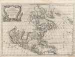
Title: L'America Settentrionale, nuouamente corretta, et accresciuta secondo le relationi pui moderne, da Guglielmo Sansone geografo an SM Chriftianis
Cartographer (personal name): William Sansone Height (inches): 18 Width (inches): 24
This map of North America and part of the British Isles shows the locations of some Indian and a few Spanish settlements. Shows the prime meridian, mentions the Seven Cities of Cibola, mentions the legendary Quivara (an alternative name for southwestern North America), and shows Greenland as a peninsula. Canada is labeled in part as New France. Shows California as an island. The central part of North America and everything north of 45 degrees North and west of the Great Lakes and Button's Bay are not mapped. Curved projection.
Item Number: 1970:02007.17 Date of map: 1775 Place of publication: Venice
Title:
Mappe
monde ou description du globe terrestre [map of the world]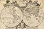
Cartographer (personal name): Francois Santini Height (inches): 18.5 Width (inches): 25.5
This map, drawn "according to astronomical observation of Sr. Janvier, geographer" sometime between 1772 and 1783 (after the voyage of Cook which disproved the notion of a large Southern Continent, but before 1783 when the Treaty of Paris disclaimed British possessions along the Atlantic Coast), shows the locations of a few communities in the Western Hemisphere and in the Eastern Hemisphere south of the Equator. It shows compass points and many routes of exploration, mentions the search for a Northwest Passage, an interconnecting waterway across North America. Greenland is drawn as a peninsula extending from Arctic land, and California is also shown as a peninsula. The northwestern portion of North America is not mapped; neither are Central and South America, much of Africa, or Australia. Deserts are shown in Africa and China. Conical projection.
Item Number: 1970:02007.18 Date of map: 1750 Place of publication: Venice
Title: Mappe monde de nos connoissances nouvelle dediee au progres [map of the world]
Height (inches): 19 Width (inches): 26.5
This undated unattributed map (circa 1750?), "dedicated to progress of knowledge and recognition of two hemispheres, one terrestrial and the other maritime," shows two hemispheres: one land, the other water. It indicates the locations of some Indians and many settlements on the Eastern Seaboard of North America and in Europe and North Africa, and shows Greenland as a peninsula north of North America. Includes the outline of Australia, four of the Great Lakes, and prime meridian line through Paris. Curved projection.
Item Number: 1970:02007.19 Date of map: 1800 Place of publication: Amsterdam
Title: Nvoua carta dell Impero del Gran Mogul [a new map of the Empire of the Gran Mogol]
Cartographer (personal name): Isac Tirion Height (inches): 11.5 Width (inches): 14.5
This map, circa 1800?, shows part of the Eastern Hemisphere, including the sub-continent of India. It indicates the locations of many people and communities in that region.
Item
Number:
1970:02007.20
Date of
map:
1776
Place
of publication:
Venice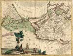
Title: Nuove Scoperte De'Russi al Nord del Mare del Sud si nell Asia, che nell America [map of the world north of the Tropic of Cancer]
Cartographer (personal name): Antonio Zatta Height (inches): 12.5 Width (inches): 16
This map shows locations of ethnic groups and communities, and mentions the legendary Quivara (an alternative name for southwestern North America). Shows New Albion in California. Canada is broadly conceived, with waterways (?) across the north related to the search for a Northwest Passage. Includes illustrations of animal life. Conical projection.
Item Number: 1970:02007.21 Date of map: 1756 Place of publication: Italy
Title: Mappa dell' America settentrionale [map of North America -- eastern portion]
Height (inches): 11.5 Width (inches): 15.7
This map notes discoveries and other historical information, with inserts partially describing the American colonies, also a line south of Hudson's Bay referring to the Treaty of Utrecht. It shows locations of some North American Indian communities, and maps the Grand Banks with descriptive and directional notes. Mercator projection.
Item
Number:
1970:02007.22
Date of
map:
1787 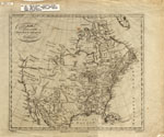
Title: North America, drawn from the latest and best authorities
Cartographer (personal name name): T. Kitchin Height (inches): 15.7 Width (inches): 18.7
This map shows states along the Eastern Seabord, mentions discoveries of the West Coast of North America, shows locations of Indian tribes and a few other ethnic groups, communities and settlements, and notes unknown heads of rivers. It mentions the legendary Quivara (an alternative name for southwestern North America). Shows New Albion in California (California is shown as a peninsula), and depicts Canada as a major area north of the present U.S. and south of New Britain and New South Wales, and depicts "mountains of bright stones," bison ("buffaloes"), and "meadows." Conical projection.
Item
Number:
1970:02007.23
Date of
map:
1807
Place
of publication:
London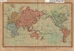
Title: The world, on Mercator’s projection
Cartographer (personal name): J. Wilkes Height (inches): 10.7 Width (inches): 15.2
This map depicts explorers' "tracks," shows locations of ethnic groups and communities, and shows Greenland as a peninsula, designated as "Old Greenland" and "New Greenland." Shows rivers on all continents except Australia. Most of these areas are not mapped: central and northern North America towards the Arctic, central Africa, central South America, and Australia. Mercator projection.
Item Number: 1970:02007.25 Date of map: 1626
Title: A new mappe of the Romane Empire
Cartographer (personal name): John Speed ["John Speede"] Height (inches): 16.7 Width (inches): 21.5
This map, produced for John Speed's atlas, shows the Roman Empire in Europe, Africa, and the Middle East. It includes many facts with much detail, and shows locations of ethnic groups and communities, with both illustrated in the margins. It has illustrations of animals in Africa and whales off of Great Britain. The map depicts Gibraltar as "the passage to the Middle Land Sea." Conical projection.
Item
Number:
1970:02007.26
Date of
map:
1651
Place
of publication:
[London?]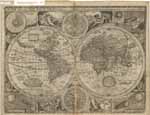
Title: A new and accurate map of the world, "drawn according to ye truest descriptions, latest discoveries and best observations that have been made by English or strangers" Height (inches): 17 Width (inches): 21.6
This map includes notes regarding voyages in the South Pacific, shows locations of communities, includes meteorological, astronomical and zodiacal information, mentioning the four elements of water, fire, earth, and air. It depicts California as an island and Greenland as a peninsula. Shows the legendary gold-rich city of Manoa and Lake Parime. Curved projection.
Item Number: 1970:02007.27 Date of map: 1626
Title: A new map of East India
Cartographer (personal name): F. Lamb Height (inches): 16.2 Width (inches): 21.2
This map, produced as part of an atlas circa 1626, shows the locations of many communities in the East Indies. Includes a detailed depiction of the delta of the Ganges and Indus rivers. Conical projection.
Item Number: 1970:02007.28 Date of map: 1776 Place of publication: Venice
Title: L'Estrenadyra e ka Castiglia nuova di nuova projezione [map of Spain and outline of Portugal, on a new projection]
Cartographer (personal name): Antonio Zatta Height (inches): 15 Width (inches): 18.5
This map shows locations of many communities in the Venice region, circa 1776. Conical projection.
Item Number: 1970:02007.29 Date of map: 1626
Title: The Kingdome of China
Cartographer (personal name): [augmented by] John Speed Height (inches): 16.5 Width (inches): 21.2
This map includes notes regarding the Great Wall of China, and shows locations of some ethnic groups. Conical projection.
Item Number: 1970:02007.30 Date of map: 1750
Title: [Untitled map of North and South America and surrounding oceans] Height (inches): 25 Width (inches): 31.5
This map, ca. 1750, shows four compass roses with intercepts for both latitude and longitude. It depicts California as an island and shows the Bay of Fundy with its tributary rivers, and to the north Canada as one large area and Nova Britannica as another area, north of New England. Mercator (?) projection.
Item Number: 1970:02007.31 Date of map: 1748
Title: L'Impero della China Per uso della Storia Generale de Viaggi
Cartographer (personal name): N. Bellin Height (inches): 11.2 Width (inches): 15.5
This map shows locations of ethnic groups and communities in China, Korea, and Mongolia.
Item Number: 1970:02007.32 Date of map: 1780 Place of publication: Amsterdam
Title: L’Amerique septentrionale [map of North America and the northern tip of South America]
Cartographer (corporate name): Royal Academy of Sciences Height (inches): 22.2 Width (inches): 26
This map, ca, 1780, includes notes re: discoveries, shows locations of Indians (Pays des Illinois, Pays des Iroquois, Terre des Esquimaux, et al.), communities in the Southwest and along the Atlantic Coast, and some of the American colonies, mentions the legendary Quivara (an alternative name for southwestern North America), and shows California as a peninsula and Greenland also as a peninsula, designated in two parts, North and South Greenland. Shows Canada as Nouveau France. Conical projection.
Item
Number:
1970:02007.33
Date of
map:
1814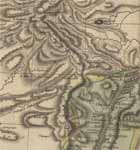
Title:
Spanish
North America
Cartographer (corporate name): Thompson Height (inches): 21 Width (inches): 28.2
This map of part of North America and Central America was drawn and engraved for Thompson's New General Atlas of 1814. It shows the locations of many Indian ethnic groups and notes many political sub-units of Spanish America. Rivers of the Southwest are included and labeled. California is presented as a peninsula with its coastline intimately delineated. The Rio Grande is labeled the Rio Bravo del Norte. The Rio de las Animas is shown, as is the San Juan River (which is called the Rio Nabajia). The San Juan Mountains are called the Sierra de las Gullas. Santa Fe is prominently shown. Although Louisiana had been purchased from France in 1807, this map shows it still separate from the United States. Conical projection.
Item Number: 1970:02007.34 Date of map: 1780 Place of publication: Amsterdam
Title: L’Amerique Meridionale [map of South America]
Cartographer (personal name): G. de L'Isle Height (inches): 22 Width (inches): 26
This map, produced for the Royal Academy of Sciences or produced from evidences by that Academy, includes many references to the routes of early voyagers, shows locations of ethnic groups and communities, mentions some navigational aids, and contains a note re: the legendary El Dorado--in Guiana. Central South America and Tierra Magellanique are unmapped. Curved projection.
Item
Number:
1970:02007.35
Date of
map:
1750
Place
of publication:
Venice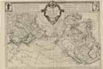
Title: Carte des nouvelles descouvertes, au Nord de la Mer du Sud, tant a l’Est de la Siberie dt du Kamtchatka, qu’al Ouest de la Nouvelle France [map of new discoveries to the north of La Mer du Sud]
Cartographer (personal name): Francois Santini Height (inches): 21.5 Width (inches): 30.5
This map of the northern hemisphere including North America and Asia includes notes re: discoveries, shows locations of Indians and other ethnic groups and communities, mentions the legendary Quivara (an alternative name for southwestern North America), and shows California as a peninsula. Greenland is also depicted as a peninsula, related to the North American land mass. Canada is broadly conceived as the whole area north of the present U.S. Quebec City and Montreal are both shown as if on Lake Huron. Conical projection.
Item
Number:
1970:02007.36
Date of
map:
1790 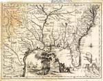
Title:
Carta
geografica della Florida dell America settentrionale [map of Florida: the
southeastern portion of the present day United States; but it includes much of
the Southwest also]
Height
(inches):
13.7 Width
(inches):
17.5
This map, circa 1790, shows locations of ethnic groups and communities, and mentions some navigational aids. The title of this map is misleading, as the area shown includes much of southwestern present U.S.; it would more properly be called a map of "Florida," i.e. the region extending from Florida towards southwestern North America. The Gulf of Mexico is not labeled. Illustrations of animals, plants and people are in the margins. Conical projection.
Title:
Amerique
septentrionale publiee sous les auspices de Monseigneurf le Duc D’Orleans
[map of North America]
Access note:
This is a large map. You have two choices for viewing it:
(1) Click here to view it as one image, 2,359 pixels high
by 2,500 pixels wide.
(2) Click here to begin viewing the map in nine portions (for faster loading),
on nine separate pages.
Cartographer (personal name): Sr. d'au Ville Height (inches): 33 Width (inches): 34.5
This map, which was prepared for an atlas compiled from the work of various authors, includes North America and the northern tip of South America. It shows the North American colonies by name, and includes a few pertinent historical notes and notes regarding coasts and islands. The map depicts locations of some Indians/ ethnic groups and communities, and shows California and Greenland as peninsulas. Canada is shown as a huge area on the eastern and northern portions of the North American continent. The central and northern portions of North America are unmapped. Curved projection.
Item Number: 1970:02007.38 Date of map: 1650 Place of publication: Munich
Title: [Untitled map of the world] Height (inches): 10 Width (inches): 13.7
The sparseness of features on this map (especially physical ones) suggests that this may be a 17th century map or chart. It resembles a Portalano type of chart. Drawings around the edges show the directions of winds. Northern and northwestern North America, western South America, northern Asia, and the Polar regions are unmapped, and Australia is not shown. This is a colorful copy made in 1910 from a map in the city library in Munich. Conical projection.
Doing your own research: This description of a portion of the collections at the Fort Lewis College Center of Southwest Studies is provided to inform interested parties about the nature and depth of the repository's collections. It cannot serve as a substitute for a visit to the repository for those with substantial research interests in the collections.
This collection is located at the Center of Southwest Studies on the campus of Fort Lewis College. Researchers wanting more information about using this material at the Delaney Southwest Research Library at the Center may email the archivist at archives@fortlewis.edu or click here to use our E-mail Reference Request Form (or phone the archivist at 970/247-7126). The Center does not have a budget for outgoing long-distance phone calls to answer reference requests, so please email if you wish to receive a response from the Center. To request reproductions/copies, click here for instructions.