
|
| Start | Previous image | Next image | End |
|
|
|
|
|
|
|
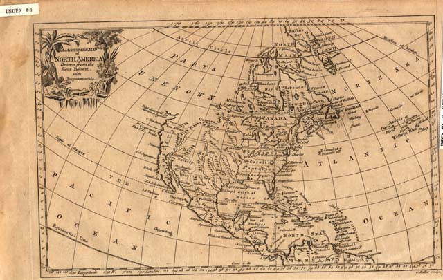
Item
Number: 1970:02007.08
Date of
map: 1750
Title:
An
accurate map of North America drawn from the Sieur Robert, with improvements
Cartographer
(personal name): Robert, Sieur
Height
(inches): 8.5
Width (inches): 14
This 18th century map
(not dated) includes mention of the westward extension of the southern
American colonies and shows locations of communities in the Southwest, East
Coast, and Central America. It
depicts Canada as a large area to the north of the U.S., California as a
peninsula, and Greenland as a peninsula separated from North America by the
Davis Straits. The entire
northwestern part of North America is unmapped.
The map includes a few notes regarding historical explorations.
Curved projection.
This
map forms part of the Cutter World Map Collection, collection C 003, at the Center of Southwest Studies, Fort Lewis
College.
© 2003 Center of Southwest Studies,
Fort Lewis College
All rights reserved (click here for Property Rights Statement).
1000
Rim Dr., Durango, CO 81301-3999 ~ Phone
970-247-7126 ~ Fax 970-247-7422
Page revised: November 14, 2003